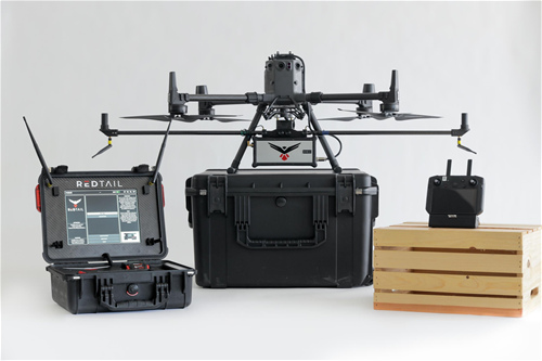
The RTL-450 incorporates a lightweight MEMS mirror and a precision navigation system to generate accurate data for the most demanding of aerial surveying missions. The high-resolution, three-dimensional point clouds created by the RTL-450 provide operators an unsurpassed ability to conduct advanced analytics of geospatial and manmade features on the earth’s surface. The RTL-450 – which is made in the U.S. – incorporates patented LiDAR sensor technology to achieve superior performance. The innovative LiDAR system, which weighs in at just over 4 pounds, is designed to operate independently of the drone platform. The modular nature of the design facilitates quick and efficient integration onto user selected platforms. To date, the RTL-450 has been integrated onto the FLIR SkyRaider, Freefly Alta-8, 4D-X6, Matrice 300 and Matrice 600. The simple and easy to use software interface – coupled with a comprehensive online training curriculum – allows system operators to be up and running in no time. The RTL-450’s high-resolution point clouds – generated at a point rate of up to 400,000 points per second and 5 returns per pulse – are extremely well-suited to numerous industry applications, including construction and resource management, infrastructure development, and precision agriculture; government customer applications include emergency response, disaster management, damage assessment, mission planning, and remote surveillance. The detail contained within the 3D images makes them ideal for use with Artificial Intelligence and Machine Learning (AI/ML) algorithms for the autonomous detection and classification of objects of interest with no human intervention required. The fact that 3D point clouds are created using the light from the pulsed laser ensures images can be collected both day and night. Receiving up to 5 returns from every light pulse transmitted enhances through canopy light penetration, thereby allowing the ground to be imaged even under heavily foliated conditions – an important capability that cannot be provided by photogrammetric imaging techniques.